1/96
Polaris GPS Navigation: Hiking, Marine, Offroad screenshot 0
Polaris GPS Navigation: Hiking, Marine, Offroad screenshot 1
Polaris GPS Navigation: Hiking, Marine, Offroad screenshot 2
Polaris GPS Navigation: Hiking, Marine, Offroad screenshot 3
Polaris GPS Navigation: Hiking, Marine, Offroad screenshot 4
Polaris GPS Navigation: Hiking, Marine, Offroad screenshot 5
Polaris GPS Navigation: Hiking, Marine, Offroad screenshot 6
Polaris GPS Navigation: Hiking, Marine, Offroad screenshot 7
Polaris GPS Navigation: Hiking, Marine, Offroad screenshot 8
Polaris GPS Navigation: Hiking, Marine, Offroad screenshot 9
Polaris GPS Navigation: Hiking, Marine, Offroad screenshot 10
Polaris GPS Navigation: Hiking, Marine, Offroad screenshot 11
Polaris GPS Navigation: Hiking, Marine, Offroad screenshot 12
Polaris GPS Navigation: Hiking, Marine, Offroad screenshot 13
Polaris GPS Navigation: Hiking, Marine, Offroad screenshot 14
Polaris GPS Navigation: Hiking, Marine, Offroad screenshot 15
Polaris GPS Navigation: Hiking, Marine, Offroad screenshot 16
Polaris GPS Navigation: Hiking, Marine, Offroad screenshot 17
Polaris GPS Navigation: Hiking, Marine, Offroad screenshot 18
Polaris GPS Navigation: Hiking, Marine, Offroad screenshot 19
Polaris GPS Navigation: Hiking, Marine, Offroad screenshot 20
Polaris GPS Navigation: Hiking, Marine, Offroad screenshot 21
Polaris GPS Navigation: Hiking, Marine, Offroad screenshot 22
Polaris GPS Navigation: Hiking, Marine, Offroad screenshot 23
Polaris GPS Navigation: Hiking, Marine, Offroad screenshot 24
Polaris GPS Navigation: Hiking, Marine, Offroad screenshot 25
Polaris GPS Navigation: Hiking, Marine, Offroad screenshot 26
Polaris GPS Navigation: Hiking, Marine, Offroad screenshot 27
Polaris GPS Navigation: Hiking, Marine, Offroad screenshot 28
Polaris GPS Navigation: Hiking, Marine, Offroad screenshot 29
Polaris GPS Navigation: Hiking, Marine, Offroad screenshot 30
Polaris GPS Navigation: Hiking, Marine, Offroad screenshot 31
Polaris GPS Navigation: Hiking, Marine, Offroad screenshot 32
Polaris GPS Navigation: Hiking, Marine, Offroad screenshot 33
Polaris GPS Navigation: Hiking, Marine, Offroad screenshot 34
Polaris GPS Navigation: Hiking, Marine, Offroad screenshot 35
Polaris GPS Navigation: Hiking, Marine, Offroad screenshot 36
Polaris GPS Navigation: Hiking, Marine, Offroad screenshot 37
Polaris GPS Navigation: Hiking, Marine, Offroad screenshot 38
Polaris GPS Navigation: Hiking, Marine, Offroad screenshot 39
Polaris GPS Navigation: Hiking, Marine, Offroad screenshot 40
Polaris GPS Navigation: Hiking, Marine, Offroad screenshot 41
Polaris GPS Navigation: Hiking, Marine, Offroad screenshot 42
Polaris GPS Navigation: Hiking, Marine, Offroad screenshot 43
Polaris GPS Navigation: Hiking, Marine, Offroad screenshot 44
Polaris GPS Navigation: Hiking, Marine, Offroad screenshot 45
Polaris GPS Navigation: Hiking, Marine, Offroad screenshot 46
Polaris GPS Navigation: Hiking, Marine, Offroad screenshot 47
Polaris GPS Navigation: Hiking, Marine, Offroad screenshot 48
Polaris GPS Navigation: Hiking, Marine, Offroad screenshot 49
Polaris GPS Navigation: Hiking, Marine, Offroad screenshot 50
Polaris GPS Navigation: Hiking, Marine, Offroad screenshot 51
Polaris GPS Navigation: Hiking, Marine, Offroad screenshot 52
Polaris GPS Navigation: Hiking, Marine, Offroad screenshot 53
Polaris GPS Navigation: Hiking, Marine, Offroad screenshot 54
Polaris GPS Navigation: Hiking, Marine, Offroad screenshot 55
Polaris GPS Navigation: Hiking, Marine, Offroad screenshot 56
Polaris GPS Navigation: Hiking, Marine, Offroad screenshot 57
Polaris GPS Navigation: Hiking, Marine, Offroad screenshot 58
Polaris GPS Navigation: Hiking, Marine, Offroad screenshot 59
Polaris GPS Navigation: Hiking, Marine, Offroad screenshot 60
Polaris GPS Navigation: Hiking, Marine, Offroad screenshot 61
Polaris GPS Navigation: Hiking, Marine, Offroad screenshot 62
Polaris GPS Navigation: Hiking, Marine, Offroad screenshot 63
Polaris GPS Navigation: Hiking, Marine, Offroad screenshot 64
Polaris GPS Navigation: Hiking, Marine, Offroad screenshot 65
Polaris GPS Navigation: Hiking, Marine, Offroad screenshot 66
Polaris GPS Navigation: Hiking, Marine, Offroad screenshot 67
Polaris GPS Navigation: Hiking, Marine, Offroad screenshot 68
Polaris GPS Navigation: Hiking, Marine, Offroad screenshot 69
Polaris GPS Navigation: Hiking, Marine, Offroad screenshot 70
Polaris GPS Navigation: Hiking, Marine, Offroad screenshot 71
Polaris GPS Navigation: Hiking, Marine, Offroad screenshot 72
Polaris GPS Navigation: Hiking, Marine, Offroad screenshot 73
Polaris GPS Navigation: Hiking, Marine, Offroad screenshot 74
Polaris GPS Navigation: Hiking, Marine, Offroad screenshot 75
Polaris GPS Navigation: Hiking, Marine, Offroad screenshot 76
Polaris GPS Navigation: Hiking, Marine, Offroad screenshot 77
Polaris GPS Navigation: Hiking, Marine, Offroad screenshot 78
Polaris GPS Navigation: Hiking, Marine, Offroad screenshot 79
Polaris GPS Navigation: Hiking, Marine, Offroad screenshot 80
Polaris GPS Navigation: Hiking, Marine, Offroad screenshot 81
Polaris GPS Navigation: Hiking, Marine, Offroad screenshot 82
Polaris GPS Navigation: Hiking, Marine, Offroad screenshot 83
Polaris GPS Navigation: Hiking, Marine, Offroad screenshot 84
Polaris GPS Navigation: Hiking, Marine, Offroad screenshot 85
Polaris GPS Navigation: Hiking, Marine, Offroad screenshot 86
Polaris GPS Navigation: Hiking, Marine, Offroad screenshot 87
Polaris GPS Navigation: Hiking, Marine, Offroad screenshot 88
Polaris GPS Navigation: Hiking, Marine, Offroad screenshot 89
Polaris GPS Navigation: Hiking, Marine, Offroad screenshot 90
Polaris GPS Navigation: Hiking, Marine, Offroad screenshot 91
Polaris GPS Navigation: Hiking, Marine, Offroad screenshot 92
Polaris GPS Navigation: Hiking, Marine, Offroad screenshot 93
Polaris GPS Navigation: Hiking, Marine, Offroad screenshot 94
Polaris GPS Navigation: Hiking, Marine, Offroad screenshot 95
Polaris GPS Navigation: Hiking, Marine, Offroad Icon

Polaris GPS Navigation

Hiking, Marine, Offroad

Navikey
Trustable Ranking Iconموثوق
31K+التنزيلات
22.5MBالحجم
Android Version Icon4.4 - 4.4.4+
إصدار الأندرويد
9.25(30-01-2024)الإصدار الأخير
3.9
(7 المراجعات)
Age ratingPEGI-3
كيفية التثبيت
1
نزّل وافتح ملف التثبيت
2
Unblock AptoideAptoide is a safe app! Just tap on More details and then on Install anyway.
3
أكمل عملية التثبيت وافتح Aptoide
app-card-icon
التفاصيلالمراجعاتالنُّسَخالمعلومات
1/96

وصف لـ Polaris GPS Navigation: Hiking, Marine, Offroad

Easy-to-use high performance GPS for wherever your travels take you. No account setup or subscriptions required.


Turn your phone into a powerful GPS navigation system with Polaris Navigation GPS, the world's #1 all-purpose GPS, and dare to go where there are no roads.


Imagine... What would it be like to navigate any waterway or explore any wilderness or city using only your phone's GPS location abilities and a view of the sky? What it would be like to create navigation destinations without the need of an internet connection and find them using only an arrow or offline maps.


That is just a glimpse of the navigational power you will hold in your hands when you install Polaris Navigation GPS.


Used mostly as a hiking, off road, nautical and trail GPS app, Polaris is an excellent backup or replacement for your handheld dedicated GPS satellite navigation unit and will keep you oriented wherever your outdoor adventures take you!


Typical usage:


● Hiking GPS with the best hiking maps!

● Back country exploration and outdoor adventure
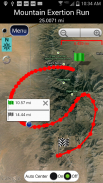
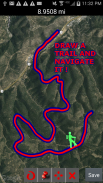
● Trail recorder

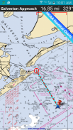
● Sailing, Boating. All marine navigation charts in Polaris are free.

● Fishing GPS. Find you favorite fishing hole.

● Hunting and hunting maps. Find you favorite hunting blind and your way back!

● Geocache

● Camping

● Mountain Biking and bike maps

● Backpacking and other outdoor sports

● Compass orienteering


Known for its stability, reliability and flexibility, Polaris is used by land-sea search and rescue, military personnel and millions of others worldwide.


To support your offline adventures we provide free of charge:


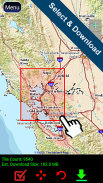
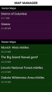
📡 Access to our vector & raster map downloaders (topos, marine, hiking and others).


📡 No limits on map types or on the number of map downloads.


📡 All maps are shown with high detail and large, easy to read labels.


This powerful navigation system also includes:


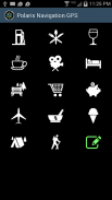
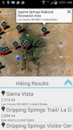
📡 Polaris Places Picker. Find hiking trails, camping locations and much more!

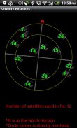
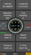
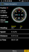
📡 GPS compass and magnetic compass

📡 GPS parameters panel

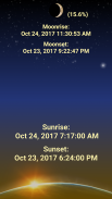
📡 Odometers, altimeters, speedometers, chronometers

📡 Split distances on tracks

📡 Draw a trail and navigate it

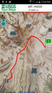
📡 Google Maps, OpenStreetMap-Mapnik, Topographic Maps, Cycle Route and Hiking Maps, Vector Maps, USGS Topo Maps, NOAA Marine Charts, World Aviation Operations Charts, Canada Toporama.


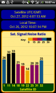
📡 Comprehensive set of GPS Tools and diagnostics

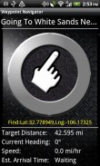
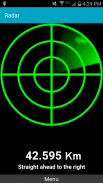
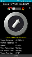
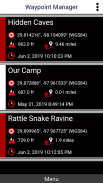
📡 Waypoint navigation system including a dynamic waypoint-finding compass that always points to your destination while reporting estimated time of arrival, distance to target and other statistics. Just follow the arrow!


📡 Trail navigation system
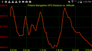
📡 Altitude profiles

📡 Location sharing

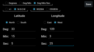
📡 Supports British OSGR and OSGB-36 DATUM (Ordnance Survey Grid)

📡 Coordinate formats: latitude/longitude as degrees, deg:min, deg:min:sec, and UTM (Universal Transverse Mercator).

📡 Military Coordinate Finder - Military Grid Coordinate Reference System (MGRS).

📡 Hiking Trails - Most of the maps show hiking paths courtesy of the Openstreetmap project. We are always amazed to find that even some of the most obscure hiking routes in our state are available.


⚓ Marine navigation- NOAA Nautical Charts and nautical unit reporting.

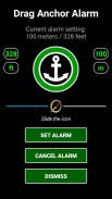
⚓ Drift alert / Drag anchor alarm.


📡 Select source for altitude reporting: Satellites, United States Geologic Survey or map your location to the results of NASA's Space Shuttle Radar Topography Mission

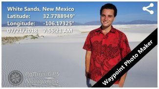
📡 Waypoint photography.


📡Map Search and Coordinate Conversion capabilities with the free MapIt! plug-in


📡 Improved compatibility for maritime navigation with addition of nautical and NOAA marine charts.


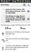
📡 Road navigation and street directions are provided through a digital pipeline connecting the power of Polaris to the Google Maps app on your device.


* The premium version of Polaris Navigation is called GPS Waypoints Navigator, available on Google Play. GPS Waypoints Navigator is ad-free and contains many other enhancements.

نظام تحديد المواقع العالمي (GPS) عالي الأداء سهل الاستخدام في أي مكان تنقلك إليه سفرياتك. لا يوجد إعداد حساب أو اشتراكات مطلوبة.


حول هاتفك إلى نظام ملاحة GPS قوي باستخدام نظام تحديد المواقع العالمي Polaris Navigation GPS ، وهو نظام GPS العالمي الأول لجميع الأغراض ، وتجرؤ على الذهاب إلى الأماكن التي لا توجد بها طرق.


تخيل ... ماذا سيكون شكل التنقل في أي ممر مائي أو استكشاف أي برية أو مدينة باستخدام فقط قدرات موقع GPS على هاتفك وإطلالة على السماء؟ كيف سيكون إنشاء وجهات التنقل دون الحاجة إلى اتصال بالإنترنت والعثور عليها باستخدام سهم أو خرائط دون اتصال فقط.


هذه مجرد لمحة عن القوة الملاحية التي ستحتفظ بها عند تثبيت Polaris Navigation GPS.


يستخدم Polaris في الغالب كتطبيق GPS للمشي لمسافات طويلة أو على الطرق الوعرة أو بحري أو درب ، فهو نسخة احتياطية ممتازة أو بديل لوحدة الملاحة عبر الأقمار الصناعية GPS المحمولة باليد وسيبقيك متجهاً أينما ذهبت معك مغامراتك الخارجية!


الاستخدام النموذجي:


● المشي لمسافات طويلة GPS مع أفضل خرائط المشي لمسافات طويلة!

● العودة استكشاف البلاد والمغامرة في الهواء الطلق

● مسجل درب

● الإبحار ، القوارب. جميع مخططات الملاحة البحرية في بولاريس مجانية.

● الصيد GPS. تجد لك حفرة الصيد المفضلة.

● خرائط الصيد والقنص. تجد لك المفضل الصيد أعمى والعودة طريقك!

● جيوكاش

● التخييم

● ركوب الدراجات الجبلية وخرائط الدراجة

● حقائب الظهر وغيرها من الألعاب الرياضية في الهواء الطلق

● توجيه البوصلة


تُعرف Polaris ، المعروفة ب الاستقرار والموثوقية والمرونة ، بالبحث والإنقاذ من البحر إلى البحر والأفراد العسكريين والملايين الآخرين في جميع أنحاء العالم.


لدعم مغامراتك في وضع عدم الاتصال ، نوفر مجانًا:


📡 قم بالوصول إلى برامج تنزيل الخرائط النقطية والمتنقل (توز ، مارين ، المشي لمسافات طويلة وغيرها).


📡 لا توجد حدود لأنواع الخريطة أو على عدد تنزيلات الخريطة.


📡 يتم عرض جميع الخرائط بتفاصيل عالية وكبيرة ، يسهل قراءتها.


يتضمن نظام الملاحة القوي هذا أيضًا:


📡 بولاريس الأماكن المنتقى. البحث عن مسارات المشي لمسافات طويلة ، ومواقع التخييم وأكثر من ذلك بكثير!

📡 GPS البوصلة والبوصلة المغناطيسية

parameters لوحة المعلمات GPS

📡 عداد المسافات ، ومقاييس الارتفاع ، عدادات السرعة ، الكرونومتر

📡 تقسيم المسافات على المسارات

📡 ارسم مسارًا وتصفحه

📡 خرائط Google و OpenStreetMap-Mapnik والخرائط الطبوغرافية وطريق الدورة وخرائط المشي لمسافات طويلة وخرائط المتجهات وخرائط USGS Topo وخرائط NOAA البحرية ومخططات عمليات الطيران العالمية وكندا Toporama.


📡 مجموعة شاملة من أدوات GPS والتشخيصات

navigation نظام الملاحة بنقطة الطريق بما في ذلك بوصلة ديناميكية لإيجاد نقاط الطريق التي تشير دائمًا إلى وجهتك أثناء الإبلاغ عن الوقت المقدر للوصول والمسافة إلى الهدف والإحصائيات الأخرى. فقط اتبع السهم!


📡 نظام الملاحة تريل

profiles لمحات الارتفاع

📡 تقاسم الموقع

British يدعم OSGR البريطانية و DATUM OSGB-36 (شبكة مسح الذخائر)

تنسيق الإحداثيات: خطوط الطول / الطول كدرجات ، درجة: دقيقة ، درجة: دقيقة: ثانية ، و UTM (مركاتور مستعرض عالمي).

Coord الباحث عن التنسيق العسكري - النظام المرجعي لتنسيق الشبكة العسكرية (MGRS).

📡 مسارات المشي - تعرض معظم الخرائط مسارات المشي من باب المجاملة لمشروع خريطة الشارع المفتوح. نحن مندهشون دائمًا لأننا نجد أنه حتى بعض طرق المشي الأكثر غموضًا في ولايتنا متوفرة.


⚓ الملاحة البحرية- NOAA الخرائط البحرية والتقارير وحدة بحري.

⚓ تنبيه الانجراف / سحب مرساة التنبيه.


source اختر مصدرًا للإبلاغ عن الارتفاع: الأقمار الصناعية والمسح الجيولوجي للولايات المتحدة أو قم بتعيين موقعك إلى نتائج مهمة طبوغرافيا رادار المكوك الفضائي التابع لناسا.

📡 التصوير الفوتوغرافي إحداثية.


SearchMap البحث وتنسيق قدرات التحويل مع MapIt مجانا! توصيل في


compatibility تحسين التوافق للملاحة البحرية مع إضافة الخرائط البحرية و NOAA البحرية.


provided يتم توفير الملاحة على الطرق واتجاهات الشوارع من خلال خط أنابيب رقمي يربط بين قوة Polaris وتطبيق خرائط Google على جهازك.


* يُطلق على الإصدار المتميز من Polaris Navigation اسم GPS Waypoints Navigator ، وهو متاح على Google Play. GPS Waypoints Navigator خالية من الإعلانات وتحتوي على العديد من التحسينات الأخرى .


Polaris GPS Navigation: Hiking, Marine, Offroad - إصدار 9.25

(30-01-2024)
نُسخ أخرى
ما الجديدV8.67MINOR BUG FIXES=====Recent:- ADD WAYPOINT INFO TO PHOTOS- MAP MANAGER FOR OFFLINE RASTER MAPS- NO LIMITS ON VECTOR MAPSV.8.20- NOAA MARINE CHARTSV.7.80- USGS TOPO MAPSV.7.72- FIND HIKING TRAILS, CAMPGROUNDS...V.7.60- MAP LIBRARY FOR OFFLINE NAVIGATIONV.7.40- TRAIL ALTITUDE PROFILESV.7.31- DRIVING DIRECTIONSV.7.12- DRAW A TRAILv.4.90- MGRS coordinatesv.4.50- Marine navigation

لا توجد آراء أو تقييمات بعد! لترك أول تقييم يرجى

-
7 Reviews
5
4
3
2
1
Info Trust Icon
تطبيق جيد نوصي بهلقد اجتاز هذا التطبيق اختبار الأمان من الفيروسات، البرمجيات الخبيثة أو أي هجمات خبيثة أخرى وهو لا يحتوي أي تهديد.

Polaris GPS Navigation: Hiking, Marine, Offroad - معلومات APK

نُسخة APK: 9.25الحزمة: com.discipleskies.android.polarisnavigation
التوافق مع أندرويد: 4.4 - 4.4.4+ (KitKat)
المطور:Navikeyالأذونات:15
الاسم: Polaris GPS Navigation: Hiking, Marine, Offroadالحجم: 22.5 MBالتنزيلات: 23.5Kالإصدار : 9.25تاريخ الإصدار: 2024-01-30 17:58:09الشاشة: SMALLيدعم CPU نوع: x86, x86-64, armeabi-v7a, arm64-v8a
عنوان الحزمة: com.discipleskies.android.polarisnavigationتوقيع SHA1: A0:D3:FD:89:A1:FC:57:F7:F5:04:26:7D:93:A0:29:81:0C:0E:3E:09المطور (CN): المنظمة (O): Disciple Skies Softwareمحلي (L): Las Crucesالبلد (C): USولاية/مدينة (ST): New Mexico

آخر إصدار من Polaris GPS Navigation: Hiking, Marine, Offroad

9.25Trust Icon Versions
30/1/2024
23.5K التنزيلات22.5 MB الحجم

نُسخ أخرى

9.24Trust Icon Versions
30/9/2023
23.5K التنزيلات22.5 MB الحجم
9.23Trust Icon Versions
21/3/2022
23.5K التنزيلات20.5 MB الحجم
9.22Trust Icon Versions
13/1/2022
23.5K التنزيلات20.5 MB الحجم
9.21Trust Icon Versions
1/10/2021
23.5K التنزيلات20 MB الحجم
9.11Trust Icon Versions
25/1/2020
23.5K التنزيلات13.5 MB الحجم
9.10Trust Icon Versions
13/10/2019
23.5K التنزيلات13.5 MB الحجم
9.07Trust Icon Versions
27/7/2019
23.5K التنزيلات13.5 MB الحجم
9.06Trust Icon Versions
6/6/2019
23.5K التنزيلات13.5 MB الحجم
9.05Trust Icon Versions
1/6/2019
23.5K التنزيلات13.5 MB الحجم

تطبيقات من الفئة نفسها

قد يعجبك أيضًا...